| Your browser is not supported. | ||
|
Please browse our site using any of the following options:
| ||
The Blue Mountains To The Snowies

One of my absolute favourite trips to take is from the Blue Mountains to Kosciuszko National Park. Leaving the hustle and bustle of Sydney for the alpine region of Kosciuszko gets me excited every time. As you drive closer to the Snowy Mountains, the changes in vegetation and environment are stark. The grass gets browner and the hills turn into mountains. Read on to learn about my recent trip, showcasing the best hikes we did in the Blue Mountains as well as the Snowy Mountains, in particular Kosciuszko NP. If you're planning a trip to these regions, definitely add these hikes to the list!
Getting There
After flying into Sydney domestic in the late afternoon, we picked up our hire car only five minutes from the airport and soon enough were on the Great Western Highway headed towards Katoomba (a small village nestled in the Blue Mountains). For this trip we were using our go-to gear hauler, the Expedition 90L duffle for carrying all our clothes and daily essentials. Such a great bag to throw around the boot of the car - you can essentially throw anything at this duffle and it won't break.


Madison eager to get on the road as we wait for our uber (left) before arriving to a misty Katoomba, my favourite kind of weather (right). (Images courtesy of Harrison Candlin)
Walls Lookout
Distance: 2.7km return
Duration: 1 hour (sunrise hours preferred)
We didn't want to waste time so we jumped straight into a sunrise hike the first morning, to a spot I'd been to before but really wanted to show Madison. Reason being this one lookout sums up just how incredible the Grose Valley and the Blue Mountains are. The hike weaves about 1.3km to the edge of the canyon, where you're greeted by 300-metre vertical cliffs. It's not for the faint-hearted and a place you really don't want to lose your footing. It's out here that you get an appreciation for the scale of the canyon walls and the valley down below. Wind howls and races up the walls like there's no tomorrow. It's definitely nature at its best.

Perfect scene for a morning hike and coffee. (Image courtesy of Harrison Candlin)


Watching the light hit the sandstone walls is such an incredible experience, and we were even greeted by some fog in the valley. (Images courtesy of Harrison Candlin)
Hanging Rock (Baltzer Lookout)
Distance: 10km return
Duration: 2 hours (sunrise or sunset)
One of the most incredible views in all of Australia and one that will surely get the knees shaking is Hanging Rock. It's about a 1-1.5-hour hike out along a 5km fire trail which you can either walk or mountain bike before you reach Baltzer Lookout. We walked but both wish we had our bikes with us! As the name suggests, Hanging Rock is a 100-metre high piece of sandstone, disconnected by 40cm from the main canyon wall (hence the name), which rises out of the Grose Valley floor and hangs over the valley. It's a jaw-dropping spot, with vistas in almost every direction and sunrises and sunsets that are nothing short of incredible with the right light. Making sure you have good footwear is essential, as the hike down to Hanging Rock from Baltzer Lookout is really steep with loose, rocky terrain. You don't want to be having any slips around here. Sheer drops of 100-200 vertical metres on the cliff edges aren't guarded by rails, so keep your wits about you at all times. There's been a shocking amount of fire damage in the area in the 2019-2020 summer bushfires, but it's great to see the vegetation on the mend and growing back.


Light hitting just right on the top of Hanging Rock (left), and Madison with the Escape Multi day pack which is perfect for these short-duration hikes (right). (Images courtesy of Harrison Candlin)
North Ramshead & Aries Tor
Elevation: 2,190m
The Ramshead Range is a wild and desolate place. Distinctively alpine terrain that's not wildly topographic by any means, but instead scattered with granite boulders and tors, most commonly known, Aries Tor. We spent an afternoon hiking to Aries Tor and we'd made a side trip up to the North Ramshead peak to bag a summit. The mountains of the Main Range are incredibly easy to climb (you can do all 10 peaks in one day if you're fit enough) and in no way resemble the big mountains you see in North America. Instead, the Main Range is an elevated plateau that's easily traversable but does attract nasty weather from the west. The most dangerous aspect up there isn't necessarily slipping or falling, but being prepared and having adequate food and gear for when the weather turns south. It's happened to me before.
To get to Aries Tor, first either hike up to Top Thredbo Station or take the chairlift (the easy way) from Thredbo itself, and start walking along the Main Range track towards Kosciuszko lookout. About 1km in, leave the track and head up the mountain to your left, weaving in and around granite boulders before arriving at the top of the ridgeline where you can now clearly see into the valley. Here are rough coordinates, but they aren't accurate. 36°29'08.9"S 148°16'18.4"E
The fun part is finding it yourself. Remember to respect the vegetation and avoid stepping on fragile environments when you can. Check out the new Terrain Tee which features Aries Tor.


Epic field testing of the new Tread TF Carbon trekking poles, which are lightweight and durable in design, and perfect for the Aussie alpine; Aries Tor (centre). (Images courtesy of Harrison Candlin)


Standing on the summit of North Ramshead at 2,190 metres (left), and taking the 15-minute ride up the Kosciuszko Express Chairlift from Thredbo to Top Station (right). (Images courtesy of Harrison Candlin)
Camping On The Sentinel
Elevation: 1,917m
The highlight and most memorable part of the trip was our last hike, an overnight camp on The Sentinel (a rocky ridgeline on the western faces of the Main Range) which is home to 400m drops on either side of the trail. Nothing really compares to camping in the Aussie alpine and there are so many places to pitch a tent - underneath rocky crags, rugged ridgelines, and more. Finding the perfect spot can be tricky, but once you find it, it's easy to sit back, relax and wait for the golden light show.
The hike starts at Charlotte Pass at an elevation of 1,837 metres. We packed our bags, the Explorer 75L hiking pack and the Escape Multi 30L day pack, fitting in all we needed for a night away. After 4km of hiking, we arrived at Blue Lake, one of only four cirque lakes in Australia. It's such a beautiful place for lunch and a good spot to dip the feet in after hiking. We weren't brave enough for a full plunge, but we did see other people getting in.


Geared up with our Expedition duffle, Explorer hiking pack and Escape Multi day pack (left), and a quick stop to refresh the weary hiking feet at Blue Lake, one of only four cirque lakes in Australia (right). (Images courtesy of Harrison Candlin)
We set up camp at around 2,000 metres above sea level, where the air temp was hovering nicely around 14°C. We popped up the Geo-2P tent, blew up the sleeping mats (Airlite 5.5 Insulated and Pro 3.8 for this trip) as well as our super lightweight and favourite sleeping bags, the Travelite 500 and Travelite 700. They've been all around the world with us and are still going strong.
We decided to pack our day pack, leave camp, and do the Sentinel Traverse in the late afternoon as shadows started to appear on the Sentinel, making it look incredibly dramatic. I was constantly saying to Madison how much this place reminded me of Switzerland. There's nothing more inspiring than a wide-open trail with mountains all around you.

The landscape along the Sentinel Traverse reminded me of the Swiss Alps - I could have stayed and taken photos for hours on end. (Image courtesy of Harrison Candlin)


Hiking the narrow trail of the Sentinel Traverse. (Images courtesy of Harrison Candlin)
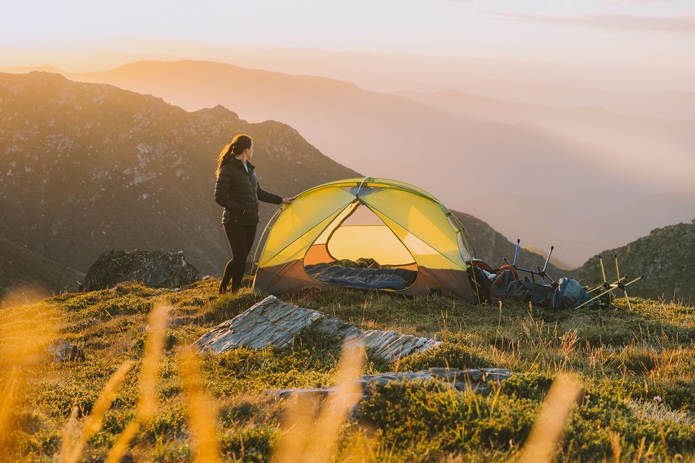
Picture perfect spot to camp. (Image courtesy of Harrison Candlin)
iPhone Moments From The Trail
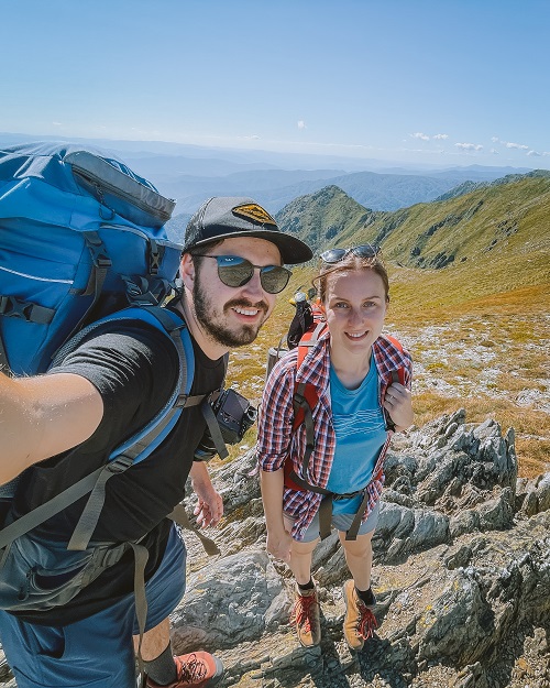
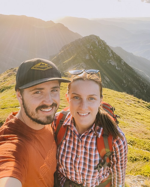
Selfies at the Sentinel. (Images courtesy of Harrison Candlin)
Photo Credits
All Images courtesy of Harrison Candlin
- Instagram @harrisoncandlin
- Website https://www.harrisoncandlin.com


